This webpage is linked/generated by QR Code for Lycian Way, Step-by-Step Lycian Way. There is a QR code for each route where all the details, updates and latest news cannot be included in the book.
For each route additional and important informations will be shared from these links. Updates, latest news, explanations, photos, so that the book will be lighter in weight. No route descriptions here, only GPS (Wikiloc) link which is included in book as well.
What is included here?
1- Up-to-date information (if there is any - the latest status about the route will be shared here)
2- Wikiloc GPS link
3- Critical spots, not to be missed points and photos
4- Warnings (spots and photos)
5- More photos to describe the whole route
Please do not forget to include a photo and description (event, status, date etc.) for informational and evidential purposes. We may share your name here with a reference if you want to.
This is a collective contribution to develop a better trail for those who will walk after you.
IMPORTANT NOTE: All articles, photos and content on this book and blog subject to Law of Intellectual Property Rights. It cannot be copied without permission, the content, photos or some part of it cannot be used without showing the source, without getting the written permission of the author and website owner.
For each route additional and important informations will be shared from these links. Updates, latest news, explanations, photos, so that the book will be lighter in weight. No route descriptions here, only GPS (Wikiloc) link which is included in book as well.
What is included here?
1- Up-to-date information (if there is any - the latest status about the route will be shared here)
2- Wikiloc GPS link
3- Critical spots, not to be missed points and photos
4- Warnings (spots and photos)
5- More photos to describe the whole route
It may be useful and helpful for you to check these links before you set off
Do not hesitate to share your opinions, revision & update requests that you might have possibly detected during your walk. All views are welcome to the email address altugsenel@gmail.com
Please do not forget to include a photo and description (event, status, date etc.) for informational and evidential purposes. We may share your name here with a reference if you want to.
This is a collective contribution to develop a better trail for those who will walk after you.
IMPORTANT NOTE: All articles, photos and content on this book and blog subject to Law of Intellectual Property Rights. It cannot be copied without permission, the content, photos or some part of it cannot be used without showing the source, without getting the written permission of the author and website owner.
19 - Demre - Finike / Wikiloc GPS kaydı - ERİŞİM için TIKLAYIN
ÖNEMLİ NOT: Bu rota İKİ günlük kamp yükü ile yürünebilecek zor bir rotadır. Bir günde bitmeyecektir. Yola çıkacakların Demre'de mutlaka alışveriş yapmalarını tavsiye ederim.
 |
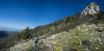
| Likya Yolu'nun Alacadağ (Masikytos) patikalarına (Gavuryolu) giriş noktası |
 |
| Antik Gavuryolu'ndan Demre Çayı ve Vadisinin görünümü |
 |
| Gavuryolu'ndan Belören'e doğru |
 |
| Belören'deki (Muskar) kilise apsisi |
 |
| Belören, Likya'nın Masikytos dağlarına açılan kapısıdır. |
 |
| Rota üzerinde bulunan çok sayıdaki sarnıçtan sadece biri |
 |
| Belören'den yukarı çıktıktan sonra Yanekin olarak bilinen mevkideki Likya Yolu tabelası |
 |
| Alakilise (Karkabo) |
 |
| Alakilise'de etkileyici detayları görebilirsiniz. |
 |
| Kırkmerdiven'den (Papazkayası) Alakilise vadisinin görünümü |
 |
| Erenler mevkisinde kısa süreliğine de olsa orman yoluna çıkacaksınız. |
 |
| Erenler'den sonra geçeceğiniz Gonca Yayla |
 |
| Karlıöz Tepesi sırtlarında yürüyüş: Likya Yolu'nun ve parkurun en yüksek noktası (1750 m) |
 |
| Karlıöz mevkisi kışın çoğunlukla karlı oluyor |
 |
| İncegeriş mevkisinde doğuda Finike-Kumluca, batıda Demre ve Kekova görülebiliyor. |
 |
| İncegeriş'ten Demre ve Kekova manzarası |
 |
| Yatıkardıç'tan sonra iniş devam ediyor. |
 |
| Belos Antik Yerleşimi |
 |
| Belos'tan sonra birkaç yayla yerleşimin de olduğu Gölbaşı mevkisine ulaşılıyor. |
 |
| Gölbaşı'nı beçtikten sonra Yalakbaşı mevkisindeki yol tabelasına kadar orman yolundan yürüyeceksiniz. |
 |
| Yalakbaşı mevkisi: Buradan sonra toprak yoldan patikaya girerek Şahin Tepesi sırtlarından Finike'ye ineceksiniz. |


